Plate Tectonics
Even though Zion National Park is not near any major plate boundaries and its collection of folds and faults is minimal, the plate tectonic activity in the area still played roles in the formation of the region. In addition to the folds and faults in the area, there is also evidence of past volcanic activity.
Folds and Faults
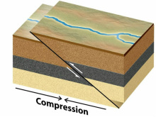
Most of the faults and folds in Zion National Park are associated with two different orogenic events, or processes in which a section of the earth's crust is folded and deformed by lateral compression to form a mountain range: the Sevier Orogeny and the Laramide Orogeny. These orogenic events occurred within the Mesozoic (252 to 66 million years ago) and Tertiary (65 to 1.8 million years ago) periods of time. Both of the orogenies are a result of lithospheric plate collisions in the area and subsequent plate subduction near the west coast of North America.
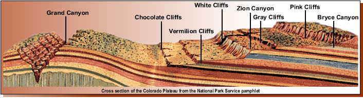
The folding and mountain building that occurred during the Sevier and Laramide Orogenies ultimately formed the base that the Zion Canyon, Bryce Canyon, and Grand Canyon are all within: The Grand Staircase. The Grand Staircase is a series of rock layers that have been folded and altered by plate tectonics. The folding created a steeper gradient and therefore made the top areas of The Grand Staircase susceptible to weathering and erosion. The canyon formations within this Grand Staircase include the Grand Canyon, the oldest and lowest, the Zion Canyon, younger than the Grand Canyon and higher up on the staircase, and the Bryce Canyon, the youngest and highest up on the staircase.
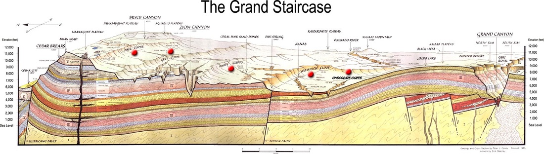
Two different views of the Grand Staircase. Both of these diagrams show Zion in relation to the rest of the staircase. However, do not be confused that the diagrams are facing opposite directions.
In addition to The Grand Staircase being formed, the uplifting of the Colorado Plateau and the tilting of the Markagunt Plateau, which started 13 million years ago, also increased the gradient of the area and made the streams within Zion National Park flow faster and downcut faster into the underlying sandstone and other rocks. This fast downcutting formed the Zion National Park canyons including the especially narrow slot canyons.
|
|
In addition to these folding processes creating ideal conditions for fast erosion and downcutting, they also created some large anticlines including the well-known Kanarra anticline. The eastern limb of this 40 mile anticline is exposed within the National Park. The western limb has been sheared off by movement in the active Hurricane Fault zone. Also, parts of the crest of the fold are exposed in certain places in the park. Other smaller folds include three minor folds throughout the park that are 495-564 feet long, 348-380 feet long, and 236 feet
|
The main faults and fault zones in the Zion National Park area are the Taylor Creek fault zone, the Hurricane fault, the Sevier fault, the Paunsaugunt fault, and other minor faults and fault zones.
The Taylor Creek fault zone is a thrust fault zone and has pushed older strata on top of younger strata. The Taylor Creek faults were generated during the Sevier Orogeny and are a result of the west to east compression forces during that orogenic event. The Taylor Creek faults displaced the strata in the area by about 2,000 feet vertically and 2,500 feet horizontally.
|
A diagram showing the movement of a thrust fault
|
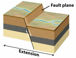
A diagram showing the movement of a normal fault
|
The other three main faults, the Hurricane fault, the Sevier fault, and the Paunsaugunt fault are all normal faults that run north to south. The faults run nearly vertically through the sandstone layers and have cut the western portion of the plateau into a series of fairly large blocks. Zion National Park lies between the Hurricane fault, to the west, and the Sevier fault, to the east, therefore making it a part of one of the blocks. The block that Zion National Park is on is bounded by the Hurricane fault and the Sevier fault.
Some of the other, lesser faults include three minor, steep, normal faults: the East Cougar Mountain fault, the West Cougar Mountain Fault, and the Wildcat Canyon fault.
|
Volcanic Activity
During the Oligocene time period (33.9 to 23 million years ago) and early Miocene time period (23.03 to 5.332 million years ago), explosive volcanic activity was prominent in the area to the west of Zion National Park. Then, during the Pleistocene time period (1.4 million years ago to 250,000 years ago) basaltic lava flowed throughout the Zion area. Almost all of the volcanic activity was concentrated near the Hurricane fault west of the main park. But, later on, a few cinder cones were constructed in the southwest region of what is today Zion National Park. In all, 13 lava flows, during the time period from 1.5 million years ago to 100,000 years ago, have been mapped in the present day park or near the park. In addition to the flows and minimal rock formations that resulted, the lava did dam up some rivers and created two lakes: Coalpits Lake and Lake Grafton.
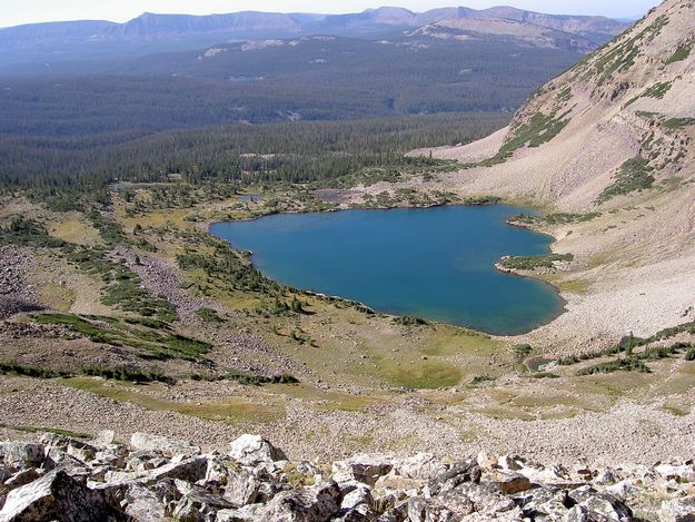
A photo of Lake Grafton
