Geological History
The Formation of the Park and Canyon was a combination of Erosion, Uplift, Lithification, and Sedimentation. Lithification acted through mineral rich waters which through pressure and time transformed compacted sediment into stone. Seabeds became limestone, mud and clay became shale, desert sand became sandstone. Each rock layer differs in thickness, mineral content, color and eroded appearance.
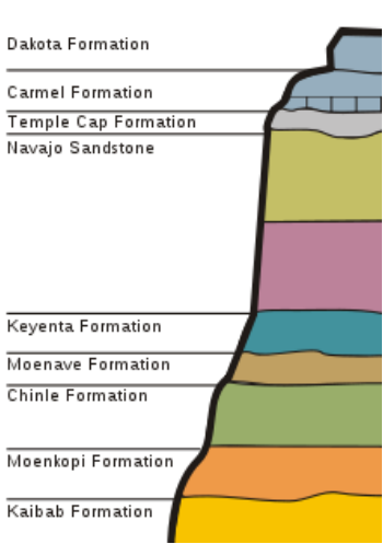
A cross-section diagram of the Zion Canyon that shows the stratigraphy of the rock layers
|
Zion Canyon is unique in its ability to showcase the different rock layers of the area. Refer to the diagram to see layer size and arrangement.
|
- Moenave Formation: You can see them as the lower red cliffs from the visitors center. This layer was formed from runoff of streams and ponds. This layer is composed of Siltstone and Sandstone.
- Chinle Formation: They are the purplish slopes above Rockville and were formed from sediments carried by streams. Composed of Shale, loose clay and conglomerate
- Moenkopi Formation: They can be viewed on the slopes from Virgin to Rockville. They were formed by a shallow sea which covered the area at the time. Composed of shale, siltstone, sandstone, mudstone, and limestone.
- Kaibab Formation: Can be viewed from the escarpment of Hurricane Fault along 1-15 near Kolob Canyons. Was formed by a shallow sea and is made out of limestone.
During the Cretacous Period interior seas covered much of the Midwestern North America. The Continent was also at a different tilt as shown on the image via the arrow pointing north. This made marine depositions and as uplift began and continued the seas gradually began disappearing as the ground rose in altitude. Currently the ground has leveled off at 10,000 feet above sea level in some places.
